Temperatures have dropped as colder arctic air spreads across the UK, with amber cold weather health alerts in place ahead of a weekend of snow forecast for much of the country.
Met Office yellow warnings for snow and ice have been issued for much of England and Wales and parts of Scotland over the course of three days, with cold conditions forecast to continue into Monday.
Separate warnings for ice are in force on Thursday and Friday after much of the UK was lashed by strong winds and heavy rain, which led to widespread flooding across the north-west of England.
A number of flood warnings and alerts stay in place in north-west England as a major clean-up operation continues after hundreds were evacuated from their homes.
Colder conditions bring to an end a run of unseasonably mild weather over the festive period, which saw highs of between 11C and 13C on Christmas Day.
Temperatures are set to be around 5C below the early January average, with a wind chill making it feel even colder.
Amber cold health alerts cover the whole of England but are not in place for the rest of the UK.
The UK Health Security Agency (UKHSA) issues the alerts when temperatures are likely to affect people’s wellbeing, in particular those who are elderly or have health conditions.
The alerts provide early warning to healthcare providers, and suggest actions such as actively monitoring individuals at a high risk, and checking that people most vulnerable to cold-related illnesses have visitor or phone call arrangements in place.
A yellow warning for ice is in place across north-west England, western Scotland and Northern Ireland until Friday morning as temperatures drop through the night.
Western Wales is also covered by a yellow ice warning from this evening until 10:00 GMT on Friday.
The Met Office also warns of snow in north-east Scotland, including the Orkney and Shetland Islands, into Friday.
Over the weekend, conditions will remain cold.
- On Saturday from noon until midnight, a yellow warning for snow and ice is in place covering all of England apart from the south-west, and the majority of Wales
- A separate yellow warning for snow covers Scotland from midnight on Sunday until 12:00 GMT on Monday
- Saturday is likely to be the coldest day as most areas will see top temperatures of around -1C to 2C
- While we are now in a chillier spell with wintry showers and potential for significant snow over the weekend for some, this is nothing unusual for winter in the UK
Age UK’s director Caroline Abrahams said the cold weather would bring the government’s decision to limit winter fuel payments “into sharp relief”, and added that the charity had already been contacted by people “worrying about what to do”.
She urged older people “to do everything they can to stay warm” including risking spending more on their heating. Ms Abrahams added that energy companies had “an obligation to help” those struggling and there may be support from local councils too.
The prime minister previously said it was important to protect pensioners who most needed the allowance, but many did not need it because they were “relatively wealthy”. The cut aims to save £1.5bn a year.

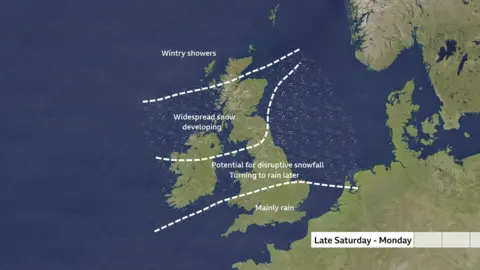
As a weather system approaches the UK late on Saturday, rain will bump into the colder Arctic air and turn to snow.
Snow will temporarily fall in parts of southern England before quickly turning back to rain on Saturday night with milder air moving in.
For Wales, the Midlands and northern England there could be as much as 5cm of snow falling to low levels and for a time, freezing rain which brings icy conditions.
As much as 20 to 30cm (8 to 12ins) of accumulating snow is possible over higher ground in parts of Wales and the Pennines. Strengthening wind blizzards and drifting snow could lead to depths of snow up to 40cm over these areas too.
There is potential for travel disruption, power cuts and some rural communities being cut off.
By Sunday and overnight into Monday, the focus of heavy snow will transfer to Scotland with an additional Met Office yellow warning in force suggesting 2-3cm of snow at low levels and as much as 20cm over higher ground.
This weather set up, where you have cold air sitting across the UK with a rain-bearing weather system from the Atlantic moving through, is a tricky one for forecasters.
How much snow and the exact locations where it will fall can be difficult to pin down more than a day ahead, leading to uncertainties in the forecast.

The Department for Work and Pensions (DWP) said on Thursday that no fresh postcodes had been triggered for cold weather payments.
Payments of £25 are made to eligible households when an area’s average temperature has been recorded as, or is forecast to be, 0C or below for seven consecutive days.
Many Britons had their new year’s celebrations accompanied by heavy rain and extensive flooding, including in Greater Manchester where a major incident was declared on New Year’s Day.
Emergency services stood down the major incident on Thursday afternoon, having evacuated nearly 1,000 people during the previous 36 hours. Flood warnings remain in place and evacuation centres have opened.
In Cheshire, the banks of the Bridgewater Canal collapsed with water pouring into surrounding fields at Little Bollington, prompting road closures and property evacuations.
The cold weather is a sharp change from December which was the fifth warmest on record, according to Met Office figures released on Thursday.
This was the general trend across the whole of 2024, which it confirmed was the fourth hottest year for the UK.
“With 2024 joining the top 10 warmest years for the UK’s annual temperature series, once again this is a clear illustration that our climate is changing, right now, and we continue to head up this warming curve,” said Met Office Senior Scientist Mike Kendon.
A warming climate also brought more rain to the country – the 2023-2024 winter was the wettest ever for England and Wales, bringing with it a record number of named storms.


